I thought I should try to explain a little around the way I am planning my circumnavigation. At least the first half of it. But before that, I should probably mention a couple of things:
First, I firmly believe we live on a sphere and that if you set off in one direction and avoid hitting land you will eventually end up where you started. So for all of you that think the earth is flat, you can stop reading now and go back to spreading conspiracy theories instead.
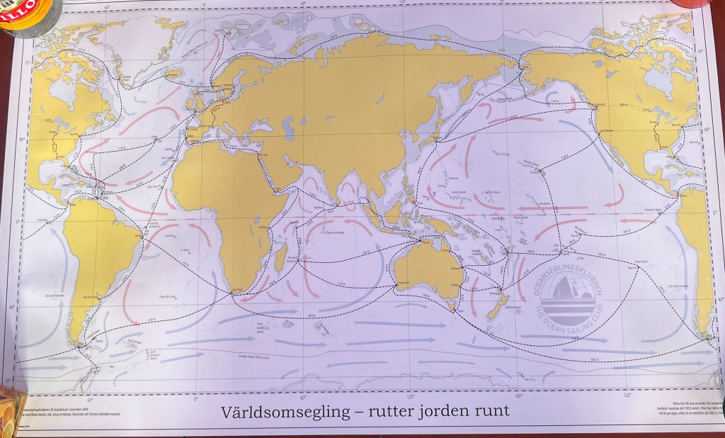
Secondly, there are many ways to sail around the world. Some routes are more challenging and some are downright dangerous. The route I am looking at this time is aimed at trying to avoid icebergs, hurricanes, cyclones and pirates. I also want to predominantly sail downwind in warm climates. Who knows though, maybe I will embark on a more challenging route if I decide to have another go once I have completed my first lap.
Lastly, I have not done this before. My plan is based on what I have read in books and learnt from fellow cruisers. I hope to revisit this post in a few years and compare notes.
So, let’s start with a simplified meteorology lesson. An area that I am in no way an expert in but one that I want to learn a lot more about. There are usually high-pressure areas located around 30 degrees north and 30 degrees south of the equator. Winds at surface level circulate clockwise around high pressures in the northern hemisphere and anti-clockwise in the southern hemisphere. This means that you should have predominantly easterly winds on either side of the equator if you sail between something like 5 and 25 degrees either side of the equator. Closer to the equator though, you have something called the intertropical convergence zone. This is an area characterised by very light winds. It is also called the Doldrums.
Further, if the surface water temperature gets too high you run the risk of ending up in a hurricane or a cyclone. They start to form at around 27 degrees C. So, if you want to sail comfortably: Sail west, in an area between 5 and 25 degrees on either side of the equator and stay on the winter side. Now, it should be noted that this applies to large bodies of open water. Land, changes in depth and currents have a tendency to mess things up.
Geographically astute readers will note that two large masses of land, the Americas and Africa, will be in your way if you attempt this. Fortunately, mankind solved this by digging two canals, the Panama and the Suez canals, that enable you to pass through these land masses. Circumnavigators of the past had no option other than to pass south of South America (Cape Horn) and south of Africa (Cape of Good Hope). For me this means that I have two big decisions to make regarding what route to take. I have taken the first one already. I’m on my way to the Panama Canal where I hope to pass to the Pacific Ocean sometime during the first quarter of next year. The second decision is whether to take the Suez Canal to the Mediterranean or go around the Cape of Good Hope. The route through the Red Sea and the Suez Canal is much shorter and probably also less challenging but it will also bring you close to some very distressed areas where there have been a number of piracy attacks. For this reason, I never really considered this route, but I understand that things may have improved lately. It still feels far from safe though. Fortunately, I don’t have to make this decision for a couple of years and in the meantime, I will keep an eye on how things develop.
My immediate plan is to get to Panama around Christmas time. The reason for this is that the trade winds that carried me across the Atlantic last year start to increase around Christmas time. When these winds reach the Caribbean basin in Central America they intensify and can bring some quite rough conditions in this area. The recommended times to sail this over 1,000 Nm leg is either in December or in April/May. Leaving it to the later weather window will either mean that I will not get to explore the Bocas del Toro and San Blas areas or force me to stay in Panama during the next hurricane season. And hurricane season in Panama means lots of thunderstorms. Something that I want to avoid if I can. Ideally, I’d like to go through the canal in March or so as that would give me a lot of time to experience the South Pacific before their cyclone season starts in November. By then I need to go to the northern hemisphere again or dodge the tropical storm belt in New Zeeland. Before I can return to the South Pacific again six months later.
Either way, that is a long time from now. Right now, I have to get to Panama in a month or so. But first I have to pick up my new passport that is waiting for me in the Dominican Republic. Sadly, this means that I will not be able to see the Bahamas this time. But I’m sure I’ll get back to the Caribbean again. Certainly if I pass the Cape of Good Hope on the home stretch. Cruising around the world may sound totally carefree and unplanned, but even this game has rules. At least if you want to enjoy it.


Discover more from Saoirse
Subscribe to get the latest posts sent to your email.

A great read, Tomas, sharing insight into the numerous layers of factors and considerations for the circumnavigator! I’ve read both Tania Aebi’s and Julie Bradley’s accounts of opting for the route of the Suez Canal when they circumnavigated — sounded rather harrowing not only due to piracy, but if I recall, both sailors mentioned the sail through the Red Sea was exhausting— to reach the Suez Canal they had to beat the entire way. So enjoy your posts and following your adventures with Saoirse! Fair winds! ~ Chelle
LikeLike
Thanks Chelle. I have also heard about people beating into sharp waves for well over a week in the Red Sea. It is over 1,200 Nm so I guess you need to carry a lot of diesel for that trip. Unless you are prepared to tack all the way. Which would make it a lot longer. At the end of the day, I think I will go for the Southern route around Cape Town. then Saint Helena, Brazil and back to the Caribbean. Best. Tomas
LikeLiked by 1 person
Hi, Tomas! The southern route you mention (going around Cape Town) is the exact route taken by another sailor/blogger here on WordPress— this couple just finished circumnavigating on their Island Packet earlier this year. You can find them at ‘Sailing Trance.’ They have a ton of great info about various ports of call in the areas you may visit. Fair winds, ~ Chelle
LikeLike
Thanks Chelle. I’ll certainly check that out. Best. Tomas
LikeLiked by 1 person
Dear Son,
it is so good to hear about your plans and that you seems to be as prepared as you possibly can be . We hope we can visit you somewhere along your route. Take care and have a lovelly time.
Your parents
LikeLike
Thanks. I really hope you can come and visit me too. Take care. I’ll put up the painting soon and send you a picture. Tomas
LikeLike
Hi Tom, good to read you are alive and kicking. I will be in the Caribbean in December but understand you moved on. Still love the Caribbean! But assume you have seen that. How about Cuba in the north? Explored that?
Anyway, interesting journey you have planned!
You probably will be confronted with the unexpected whatever route you take – but that is part of fun! Love to hear your Cape Town crossing adventures – pretty big waves there I have heard. Good luck – Bas
LikeLike
Hey Bas. Where in the Caribbean will you be? I think I will go directly to Panama from Dominican Republic. There are so many places to see everywhere but it’s just not possible to do it all. At least not this time around. Cuba is one of them. Cartagena and the ABC islands are two more.
All sailing plans are vague. In fact, long-distance sailors never say that they sail to a particular place, they say they sail towards a place. And the Agulhas Current off the east coast of South Africa is notorious and one of the most dreaded passages for circumnavigator. Enjoy your vacation, Bas. All the best. Tom
LikeLike